Structure patrimoniale inscrite au répertoire
Blundon House
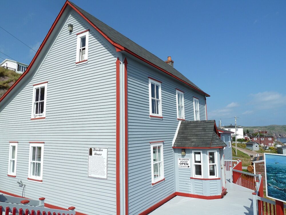
Absente du Répertoire. Photo: Robthepiper, Wikimedia Commons · CC BY-SA 3.0
- Construction
- 1896
- Reconnaissance
- 1997
- Par
- Heritage Foundation of Newfoundland and Labrador
Le texte du répertoire, mot pour mot
Description
The Blundon House is a two and one half storey house built on a gable-ell plan, located at 7 Blundon’s Point, Bay De Verde, NL. The designation is confined to the footprint of the building.
Valeur patrimoniale
The Blundon House has been designated as a heritage structure because of its aesthetic value, historical associations and cultural value.
Aesthetically, the building is of value as it is a good example of merchant class housing. Constructed in the late 1800s, the exterior accents and ornate detailing set this house apart from others in the community and speak to its ownership by an upper class family.
The building is historically important because it is the last remaining merchant house in Bay De Verde and one of only a few on the lower North Shore of Conception Bay. It is associated with the Blundon family and their role as merchants in the community. The original owner John Blundon, was a successful local merchant who owned several schooners involved in coastal trade. His son James, who was also a merchant, lived in the house as well.
The building has cultural value as it is representative of a particular time and place. In a community context it is a physical reminder of class distinctions in the late 1800s and early 1900s in outport Newfoundland. The house was designed with a separate servants’ quarters, a tangible physical demarcation highlighting the differences in the lifestyle between that of merchant and employee.
SourceHeritage Foundation of Newfoundland and Labrador property designation file M-030-020, Bay De Verde - Blundon House
Éléments caractéristiques
All those architectural features which speak to the age, construction and prominent local design of a merchant's dwelling, such as:
-gable-ell plan;
-number of storeys;
-gable roof with kicked eaves;
-five-sided porch with gable roof and bay windows;
-location of porch on front facade;
-window size, style, trim and placement;
-size, style, trim and placement of exterior doors;
-detailing on raincaps and cornerboards;
-narrow clapboard;
-style and placement of chimneys; and -location and orientation of building.
Fin du texte du répertoire
Emplacement
48.08640° N, 52.89852° W
Itinéraire (s’ouvre dans un nouvel onglet)L’inscription au répertoire ne rend pas un lieu accessible au public. Beaucoup sont des résidences ou des commerces privés; admirez-les depuis la rue.

Chargement de la carte…
À proximité
 John Parot's Grave Municipal Heritage Site7,9 km · Old Perlican
 Beckett Property8 km · Old Perlican · 1902
 Lieu historique national du Canada du Paysage-des-Murs-de-Grates Cove9,3 km · Grates Cove · 1790
 Shano/Le Shane Property Registered Heritage Structure10 km · Lower Island Cove · 1860
 Aubrey and Elizabeth Crowley Property23 km · Ochre Pit Cove · 1910
Lieux semblables
Les lieux dont la description du répertoire se rapproche le plus de celle-ci.
Tiré du Répertoire canadien des lieux patrimoniaux, dans sa dernière mise à jour du 12 décembre 2025. Le texte du répertoire est reproduit mot pour mot.