Structure patrimoniale inscrite au répertoire
007 Monkstown Road
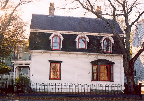
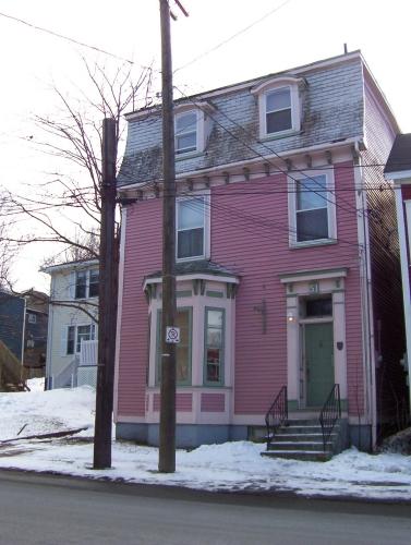
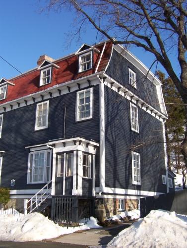
Photo: HFNL 2005
- Construction
- 1860–1889
- Reconnaissance
- 2005
- Par
- Heritage Foundation of Newfoundland and Labrador
Le texte du répertoire, mot pour mot
Description
This two-and-a-half storey wooden dwelling is located at 007 Monkstown Road, St. John’s. The designation is confined to the footprint pf the building.
Valeur patrimoniale
007 Monkstown Road has been designated for its aesthetic and historical values.
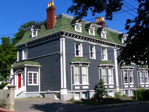
007 Monkstown Road is aesthetically valuable because this structure is a fine example of Second Empire (modified) architecture. It is much more elaborate in style then the Southcott Second Empire designs which became very typical after the 1892 Great Fire. This is reflected in the dormer windows with its saw-tooth decorative work, single storey bow window, the decorative brackets, fascia, frieze with its panel and roundel modified pilasters.
007 Monkstown Road has historical value because of its assocations with John S. Curie. Currie, politician and journalist, resided there. Mr. Currie was elected to the House of Assembly in 1913 as the member of the Burin District until 1920. During his time in government he helped to organize the Permanent Marine Disaster Fund. This fund was provided for dependants of any fisherman or seaman who was injured or killed in a marine disaster. In 1916, Mr. Currie became editor of the Daily News; a position he held until his death in 1956.
SourceHeritage Foundation of Newfoundland and Labrador unnumbered property designation file - St. John's, 7 Monkstown Road.
Éléments caractéristiques
All those elements that embody the Second Empire design, including;
-narrow wooden clapboard;
-window openings and fenestration;
-covered verandah with decorative spindle work;
-original entrance door with transom and small shelf decoration;
-the decorative fascia;
-frieze with its panel and roundel motif;
-detailed saw-tooth designs on dormers and pilasters;
-returned eaves;
-two three pot chimneys; and -mansard roof with extended steep gable pitch.
Fin du texte du répertoire
Emplacement
47.56904° N, 52.70889° W
Itinéraire (s’ouvre dans un nouvel onglet)L’inscription au répertoire ne rend pas un lieu accessible au public. Beaucoup sont des résidences ou des commerces privés; admirez-les depuis la rue.

Chargement de la carte…
À proximité
Les 222 lieux de St. John's 7 Monkstown Road Municipal Heritage Buildingà moins de 100 m · St. John's
 010 Barnes Roadà moins de 100 m · St. John's · 1892
 008 Barnes Roadà moins de 100 m · St. John's · 1892
 Peppercorn House Municipal Heritage Buildingà moins de 100 m · St. John's · 1870
 30 Queen's Roadà moins de 100 m · St. John's · 1900
 034 Queen's Road100 m · St. John's · 1854
Lieux semblables
Les lieux dont la description du répertoire se rapproche le plus de celle-ci.
Tiré du Répertoire canadien des lieux patrimoniaux, dans sa dernière mise à jour du 12 décembre 2025. Le texte du répertoire est reproduit mot pour mot.